Cupid, that Ancient Roman love God is now the subject of a Valentine’s Day math activity that involves a map, a distance chart, and some open-ended questions. If it sounds familiar, you have probably encountered Santa’s Route which is an activity that has been on the website for years, but got an overhaul for this past Christmas. Due to the popularity of the Christmas version, I thought why not make a “route” activity for every holiday page.
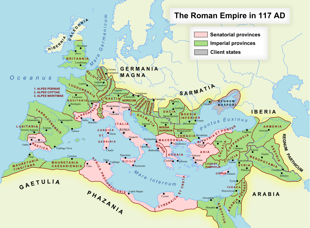
I thought it would be more fun and cross-curricular to set the activity in Ancient Rome in the year 117 C.E. at the height of the Roman Empire. Cupid is, of course, an Ancient Roman God and would have been familiar to Romans in 117 as he is today. The scenario is that Cupid must fly to 12 cities to help people fall in love with his golden arrow. Students are asked to try to find the shortest route given various start, end and open-ended cities. Visit the Cupid’s Route activity on Math-Drills. Note that this will bring you to the “U.S. Units” version, but the “Metric” version in km is just a button click away in the other versions section.

This is essentially the “traveling salesman” problem with some slight modifications. If you are familiar with the traveling salesman problem, it can become very complicated especially with larger numbers of stops. In this case, 12 is fairly manageable and students can come up with a reasonable solution, especially if they use the included map or the linked Google map. Teachers and parents are cautioned that students may not come up with the best/shortest solution, so they should be scored on their mathematical thinking and reasoning rather than a mark for getting the “right” answer.
The map included with the activity is in the public domain and available in a high resolution from Wikemedia Commons. There is a link to it on the map page in the activity. This might be useful if you wanted to use a version on the screen rather than a paper copy or if you wanted to print a larger or higher resolution version. There is also a Google My Maps version linked from the map page that is pre-populated with the cities in the activity. The Google map is a different map, but can be copied into another Google account and edited. The line tool will make creating a route quite easy.

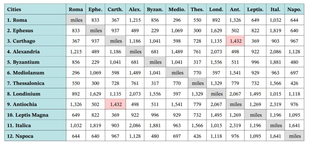
The distance chart is based on the measurements from the Google map, so if students are using the Google map for this activity, they should find the same distances as shown in the chart. They might differ by a mile or two due to unit conversion (I started in km). If they are using the Ancient Rome map, they will have to use the chart to determine the distances between cities.

There are many opportunities to use this activity in other ways and for cross-curricular activities. This could be a computer programming activity; in fact, this is how I came up with the shortest routes myself. Besides the obvious connections to history, students could also use the scenario as a creative writing activity. Reading stories involving Cupid could also be interesting and enlightening and perhaps a pre-cursor to writing their own stories. Sculpture, engineering, painting, politics, food… the Ancient Romans are a great source for material.

